N0YWAMKISK
(Where the Sand Blows...)
Vignettes of Bay St. George Micmacs
will kill only one Wild Goose or two, sometimes three, and this does not suffice to support them and their families as a big animal does.
Source: 1672 Nicolas Denys, The Description and Natural History of the Coasts of North America (Acadia) Toronto: The Champlain Society 1908, pp. 186-7.
4, 5. A central theme in discussions of Newfoundland Micmac history is the likelihood of crossing sixty-five miles of open sea in birchbark canoes. Major Rogers, below, talks of the navigational knowledge possessed by Micmacs which would make such voyages possible. In the next piece, (#5), Frank Speck describes how they crossed from Cape Breton to Cape Ray.
The Indians do not want for natural good sense and ingenuity, many of them discovering a great capacity for any arts or science, liberal or mechanical. Their imaginations are so strong, and their memories so retentive, that when they have once been at a place, let it be ever so distant, or obscure, they will readily find it again. The Indians about Nova Scotia and the Gulf of St. Lawrence have frequently passed over to the Labrador, which is thirty or forty leagues, without a compass, and have landed at the very spot they first intended: and even in dark cloudy weather they will direct their course by land with great exactness; but this they do by observing the bark and boughs of trees; the north side, in this country, being always mossy, and the boughs on the south side the largest.
Source: 1765 Major Robert Rogers, A Concise Account of North America... London: J. Millen, p. 209. The Newfoundland Indians... are known to both themselves and the Micmacs of Cape Breton as Ta-yi'mku-yewd x [Taqamkukewa'q], "people of the land across the water." The island itself is known as Ta'-yamkuk' [Kta-qamkuk]. According to the tradition current among Newfoundland Micmacs, the Micmac of the mainland had always some knowledge of the Island through their own excursions by canoe. The route lay between Cape North and Cape Ray on the southwest coast of Newfoundland, a distance of sixty-five miles, land being dimly visible in fine weather. This bold journey was
Source: 1922 Frank Speck, Beothuk and Micmac. New York: Museum of the American Indian, Heye Foundation, pp. 119-120.
6. Below is described the kind of knowledge of land and skies which allowed Micmacs to travel over great distances without the forms of transport or navigational tools needed by Europeans.
... especially does the Micmac know about Nova Scotia and the places adjacent. Show him a map of these places, and explain to him that it is "a picture of the country," and although it may be the first time he has ever seen a map, he can go round it, and point out the different places with the utmost care. He is acquainted with every spot. He is in the habit of making rude drawings of places for the direction of others. One party can thus inform another at what spot in the woods they are to be found. At the place where they turn off the main road, a piece of bark is left, with the contemplated route sketched upon it. The party following examine the luskun as they term it, when they come up, and then follow on without any difficulty.
... Besides their accurate acquaintance with the face of the country, they are able to track you with all ease over the leaves in summer. They can discern the traces of your foot, where you can see nothing. You have bent the leaves and grass under your feet, and the impression remains. And your upper extremities have left an additional track behind you, on the trees, and on the moss, which, brushed along as you passed, was not wholly elastic; it remained in a measure as you left it. So that whether he looks up or looks down, he sees your track, and can follow you at full speed.
... They have watched the stars during their night excursions, or while laying wait for game. They know that the North star does not move, and they call it 'okwalunuguwa kulokuwech[oqwhatnukwy kloqowej]," "the North star." They have observed that the circumpolar stars never set. They call the Great Bear, "A/uCTi[mui'n]," [the bear]. And they have names for several other constellations. The morning star is ut'adabun[ut&'tapn], and the seven stars ^u/^uc/i[ijulkuj]...
Source: 1850 Silas Rand, Short Statement of Facts relating to the History, Manners, Customs, Language, and Literature of the Micmac Tribe of Indians, in Nova-Scolia and P E. Island. Halifax, N.S., pp. 25-26.
7, 8. The piece below is one of several references to a treaty signed by the Micmacs of Bay St. George and the English. However, a copy of the treaty has never been found. The date is about the same time as many authors, such as Chappel (#9), give as the time of the Micmacs' arrival in Newfoundland. If they had just arrived, it seems strange that Thompson would feel it necessary to arrange a treaty with them. In the next piece (1f8), William Taverner establishes the Micmacs' presence near Cape Ray in 1715.
Captain Thompson, of his Majesty's ship Lark, was more successful with another tribe. He was cruising, in September, 1763, as Surrogate, along the south-west part of Newfoundland, when he observed a large party of the Indians, called Mickmacks. Having had a conference with their chiefs, he succeeded in concluding with them, in the name of the whole tribe, a treaty, by which they engaged themselves to live in strict friendship with the subjects of Great Britain wheresoever they should meet them, and to give their assistance against the enemies of the King of Great Britain, as long as the sun and moon should endure.
Source: 1819 C. A. Anspach, History of the Island of Newfoundland: containing a description of the Island, the banks, the fisheries and trade of Newfoundland, and the coast of Labrador. London: printed for the author and sold by T. & J. Allman and J. M. Richardson, p. 182.
Some Remarks on the present State of the South Part of Newfoundland humbly ofre'd to the Honble. the Lords Commrs. of Trade and Plantations by Wm. Taverner [1715]
.. .The French Inform me that about Cape Ray was abundance ofFurrs, that the Martin there was the Largest and Finest in the world, that some hunters had on the Coast soon a Thousand Deer in a Company, that the Indians, from Cape Britton did frequently come there in shallops to Furr and hunt the winter season...
Source: Provincial Archives of Newfoundland and Labrador, CO 194/6 ff 47.
9, 10. Chappel's account, below, of his meeting with Micmacs at Seal Rocks gives us considerable information about their history in Bay St. George. He refers to land granted to the Micmacs in Bay St. George. By Chappel's reckoning, the Micmacs arrived in the area in the late 1700s. While earlier records indicate their presence before that, there were large permanent migrations of Micmacs and Acadians to Bay St. George after Cape Breton became British property in 1763. The next piece (#10) mentions that event.
During our war with America, between the years 1775 and 1782, the Micmac Indians... were amongst the number of our most inveterate enemies; but at length one of our military commanders, having concluded an amicable treaty with them, he selected one of the most sagacious of their Chiefs to negotiate a peace with a neighbouring tribe... The old Indian ambassador succeeded in the object of his mission; and received, as his reward, the grant of a sterile tract of land in St. George's Bay, Newfoundland, together with permission to transport as many of his countrymen thither as might be willing to accompany him in the expedition. Accordingly, the old Sachem left his native land, accompanied by a strong party of Indian followers; and boldly launching out to sea in their own crazy shallops or canoes, they eventually reached St. George's Bay in safety.
Such instances of bold navigation are not unusual amongst the Indians of North America, and particularly those of Nova Scotia. Without compass or chart, they are not perplexed in traversing the most boisterous seas or trackless deserts: necessity has taught them to be guided by natural appearances...
The first act of the Micmacs, upon their arrival in Newfoundland, was to appoint the old Indian, who had conducted them thither, their Chief in perpetuity; and they next "buried the sword," as a symbol that war had for ever ceased between their tribe and the English nation. Since this period they have been making a gradual progress towards civilization: and by frequent intermarriages with the European settlers at Sandy Point, the race became so intermingled, that, at the time we visited them, the number of pure Indians did not exceed fifty, exclusive of women and children... the Micmacs have frequently changed their abode to different places within the limits of St. George's Bay. They had, however, resided about nine years in the spot where we found them...
Source: 1818 Lieut. E. Chappel, Voyage ofHMS Rosamond to the Newfoundland and the Southern Coast a/Labrador. London: J. Mawman, pp. 76-78, 85.
10.Combined with these three peoples [Scots, Irish and French in the Codroy Valley] were a few English settlers-with fishing as their intent, and a few Micmac Indians who had sought shelter in Newfoundland after Nova Scotia had been taken over by the British. The influence of the latter two peoples was soon overshadowed by the other three, although no doubt there have been important contributions made by all.
Source: Folklore and Language Archives, Memorial University of Newfoundland, 71-39, p. 129.
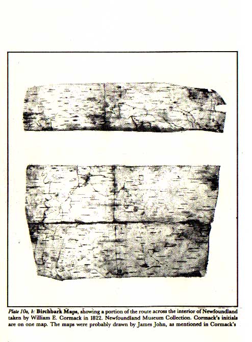
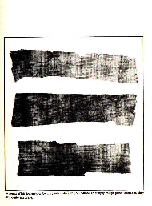
11. Cormack's mention of being the first white man seen by the Micmacs he met in the interior is significant/or what it says about the separateness of Micmac and white territories in Newfoundland. According to Cormack, the Micmacs still spoke only their own language at a date late in the white settlement of the island, also indicating very little contact between the two groups.
My dress... was seen by some of the Indians as we emerged from a spruce thicket, a great distance off. The party were encamped in one large wigwam, or kind of hut [near Lake Maelpegh]. We entered with little ceremony... None of them could speak English, and only one of them a little French... They were Mickmacks and natives of Newfoundland, and expressed themselves glad to see me in the middle of their country, as the first white man that had ever been there.
Source: 1824 W. E. Cormack, "Narrative of a Journey Across the Island of Newfoundland in 1822," in 1915 J. P. Howley, The Beothuks or Red Indians, Cambridge University Press, pp. 150-151.
12. The following passage shows that close ties between west coast and Cape Breton Micmacs continued to a relatively late date. It also suggests that, even in 1840, the Micmacs had quite definite ideas about who controlled Newfoundland, and it was not a European power. The "Indian King" would be the Chief of the Grand Council of Micmacs based in Cape Breton.
One Indian woman [Micmac, in St. George's], middle-aged and apparently intelligent, began talking about the 'Indian king.' She said that they had a 'king' who resided in Nova Scotia, that the whole country rightly belonged to him, and that he must be consulted before any of them dare give me any information.
Source: 1842 J. B. Jukes, Excursions In and About Newfoundland During the Years 3839 and 1840. London: John Murray, p. 176.
13. Below is a statement from the late 1800s, since repeated by many Micmacs and scholars, about European ignorance of the interior of the island. Perhaps the ancestors of the Micmacs mentioned here were the Sa''7^we"djki'k[Saqawe'jkik], or "the ancients," who, according to Frank Speck's account of the oral history of Newfoundland Micmacs, came to Newfoundland long before the Europeans. They are said to have merged with the families who migrated from Cape Breton in the 17th and 18th centuries.
Sir William Dawson, FRS, informs us... that the Mic-Macs of Nova Scotia have traditions of a primitive people whom their ancestors had driven from Nova Scotia into Cape Breton, and pursued into Newfoundland across the comparatively narrow sea separating the two islands... So entirely ignorant were the white inhabitants of the coasts of the interior of the island, that possibly the Mic-Macs had effected a permanent settlement in the country long before their presence was suspected.
It seems singular that so little was then known [in the late 1700s] of an island that had nominally been a British possession for a couple of centuries. However, after the lapse of more than another hundred years the coasts alone have been thoroughly explored. One or two enterprising travellers have indeed visited the great lakes and rivers, but except to them and a few hunters and trappers, the interior remains as much as ever 'terra incognita.'
Source: 1888 Edith Blake, "The Beothuks of Newfoundland" in The Nineteenth Century December, p. 906.
Where did they live?
Historical records show that the Micmacs travelled across the entire southern and western interior and into the northwestern interior. According to available records, the earliest permanent settlements were in the Codroy Valley and Bay St. George. Archeology could show if there had been prehistoric occupation if remains of old settlements were found. However, as yet, there has been only one brief archeological survey on the west coast.
The settlements in the Codroy and Bay St. George became increasingly surrounded by white settlements. In the late 1700s part of the Micmac population expanded around the south coast as far as Conne River. Micmacs remained in the Codroy until the 1940s and they still remain in Flat Bay, St. Georges, Port au Port East and other communities in Bay St. George and the Port au Port peninsula. Some moved north to settle in the Bay of Islands and the Northern peninsula. In the early 1900s some Micmacs from Conne River moved to the new railway towns ofGlenwood and Badger, where they joined Micmac families already living in the area. They were the Francis family in Gander Bay and the Paul family and others in the Badger area. Others, like the Strides, returned to Bay St. George from Conne River.
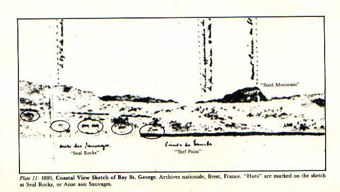
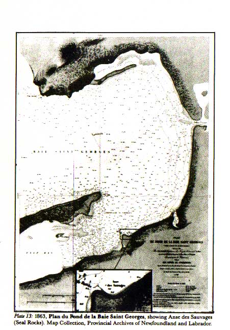
The principal settlement of Micmacs in St. George's during the 1700s and 1800s was at Seal Rocks, part of the present-day community of St. George's. In the early part of the 1800s, Bay St. George was the centre of the Micmac population in the island, but the population shifted by the middle of the century. By 1857, according to the census, one-third of the population was in the Great Codroy area, one-third in Bay d'Espoir, and the remaining third were spread from Grandy's Brook to Exploits Bay. A reason for this move may have been that until 1850 there was no Roman Catholic priest resident on the west coast. Micmacs would travel to St. Pierre in order to see a priest, and may have decided to remain on the south coast where they were closer to him. There still was, however, a significant concentration of population at Seal Rocks in Bay St. George until the end of the 1800s, but it had dispersed by the early 1900s.
The circumstances surrounding the Micmacs' departure from Seal Rocks are not known. By the time the railway came through, virtually completing the move of the white community from Sandy Point to the Seal Rocks side of the bay, the Micmacs were already gone. We have hints of what may have happened from the records, but the story is not complete. A lobster factory was established at Seal Rocks at the end of the 1800s. A series of letters from the first years of the 1900s between the Governor and government officials was concerned with a dispute over the sale of land south of Seal Rocks extending toward Flat Bay through present-day St. George's. The records of both these actions do not mention the presence of a Mic-mac settlement. It is likely that the Micmacs were in the process of moving to St. Theresa's and Flat Bay, where the greatest concentration of their west coast population is today. We may assume, in all parts of Bay St. George, that the pressures of development and increased white settlement pushed the Micmacs further and further away from the new population centres. Some families remained where they were and adjusted to their white neighbours. They are those still living in St. George's, Stephenville Crossing, Port au Port East, and other primarily white communities in the area. The early adjustment between Micmacs and whites worked both ways. A new way of life developed in Bay St. George through the sharing of skills and resources by the two groups.
Increased white settlement and industrial development meant that Mic-mac communities became isolated from each other. Changes in white attitudes caused social differences and prejudice to develop. These affected the former patterns of sharing and led to isolation of Micmacs from whites. White settlement and industrial developments destroyed much ofMicmac hunting lands. Yet there is almost no recognition of these events in the white historical record. Instead, as at Seal Rocks, there are references to the presence of Micmacs at one point, and then later references to land purchases and settlement by whites in the same area. But the upheaval which such actions produced in the lives of the Micmacs who were living there is not mentioned. It is as if, for the white officials and settlers, the Micmacs ceased to exist.
Throughout this century, Micmacs have remained in Bay St. George in fairly constant, although often unnoticed, numbers. The 1945 Newfoundland census showed significant numbers of people from the Codroy to Bay St. George who defined themselves as "Micmac," "Indian" or "French Indian." The descendents of those people, and others who have been historically documented as Micmac, led to the collection of genealogies including over 700 people in a 1984 research project. That research covered only some of the Bay St. George and Bay of Islands families and most of Glen-wood and Gander Bay. If the remaining research for families for whom some documentation exists is completed, the number would probably double.
In this section, we will look at where Micmacs traditionally lived and travelled in Newfoundland, and where and how they came into contact with whites. Their contact with other native groups is also discussed.
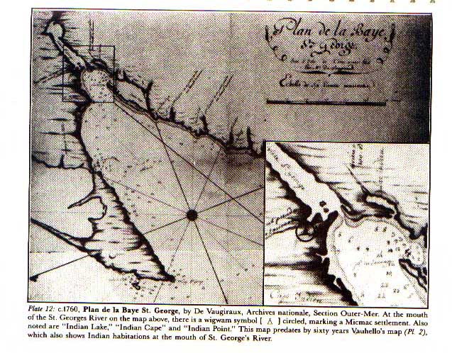
1, 2. The log passages below report Micmacs in Bay St. George in the second half of the 1700s. The French map opposite, from about 1760, shows a Micmac encampment at the mouth of the St. George River. Wednesday 20 [May 1767] St. George's Harbour... Found here a Tribe of the Mickmak Indians.
Source: 1767 Log Book of the HMS Grenville, Captain James Cook's survey ship. Public Record Office (U.K.), ADM 52/1263 67834.
2.The same tribe of Indians, consisting of thirty families which were in St. George's Bay last year were there again this, and, as before their traffick wholly confined to the French.
Source: 1788 Report by Captain Reynolds of HMS Echo. Provincial Archives of Newfoundland and Labrador, CO 194/21 ff 172.
3, 4. The/allowing two pieces, from the mid-1800s, describe where the Micmacs lived and their hunting and trading patterns. The population numbers given are consistent with the previous piece.
All the Indians in the Island, exclusive of the Red Indians, amount to nearly a hundred and fifty, dispersed in bands, commonly at the following places or districts:-St. George's Harbour and Great Cod Roy River on the west coast; White Bear Bay, and the Bay of Despair on the south coast; Clode Sound in Bonavista Bay on the east; Gander Bay on the north coast, and occasionally at Bonne Bay and the Bay of Islands on the north-west coast. They are composed of Mickmacks, joined by some of the mountaineer tribe from the Labrador, and a few of the Abenakies from Canada. The Esquimaux, from Labrador, occasionally, but seldom, visit the Island. There are twenty-seven or twenty-eight families altogether, averaging five to each family, and five or six single men.
Source: 1824 W. E. Cormack, "Narrative of a Journey Across the Island of Newfoundland in 1822," in 1915 J. P. Howley, The Beothuks or Red Indians, Cambridge University Press, PP. 151-152.
There are in the island about 40 families of Micmac Indians, amounting to 200 men, women and children. They subsist principally on venison, which they kill in the neighbourhood of the lakes to the N.E. of St. George's Harbour. They employ themselves in hunting the martin, otter and beaver, and sell the skins, sometimes to the establishment of Messrs. Newman, in the Bay of Despair, and sometimes to the traders who occasionally touch at St. George's Bay and Bay of Islands. They are all of the Roman Catholic persuasion, and are a timid and inoffensive people. They generally pass the winter near the south coast, in the vicinity of Bay Despair, and in their hunting excursions in the summer, traverse the island between the south and west shores and the Bay of Exploits on the northern coast. They thus continually pass over the tract of country which was formerly inhabited by the Red Indians.
Source: 1839 The Public Ledger 19 November. Newspaper Collection, Provincial Archives of Newfoundland and Labrador.
5. Below, Speck gives a description of the movements of Micmacs within the island. He mentions a site where Micmacs and Beothuks lived together, said by some in Bay St. George to have been on the St. George River. His map on the following page shows Micmac settlements across the island at the time of his visit in 1914.
Indeed, the great-grandfather of Mathew Mitchell, who was a captain, or sub-chief, is said to have received a sloop as a present from the French king in order to facilitate the movements of the Micmac on the water in the interests of France. Then, as the numbers of the Micmac increased, their settlements were extended from the west coast to the southern coast and later into the interior. The first settlements were about St. George's bay, Noywa'mkisk [Nujio'qon], "where the sand is blown up by the wind." On the south coast the Micmac located at Burgeo, Ma'-yeme 'gwik [Maqme'kwik], "big fish river," and Asiktci'gamuk [Asikikamuk],"on the other side of the land (toward the sea)," now called Connel river. These and other villages on the northern coast, settled after the withdrawal of the Beothuk into the interior, will be found marked on the accompanying map, (next page).
In the St. George's Bay region, supposedly near the present village of

Stevensville, the Micmac remembers that his ancestors lived in at least one village in company with the Beothuk, whom they term Meywe 'djik, "red people."
Source: 1922 Frank Speck, Beothuk and Micmac. New York: Museum of the American Indian, Heye Foundation, pp. 121-122.
6. The letter below indicates considerable cultural and social contact between the Mon-tagnais Indians of Labrador and Quebec and the Micmacs of Bay St. George and Cape Breton.
I met some [Montagnais] from the Bay of Seven Islands, who went... to Bay St. George, where the Mique Maques have a settlement of 60 families, and from thence across sea to Cape North and Sydney Cape Breton, who had never before seen a priest, but had been instructed in the rudiments of Religion by the Mique Macques... They have often brought from Newfoundland the corpses of their people, who died in the winter to be buried, in the summer, in the Indian burying ground in a small Island in the bottom of the Bras d'Or Lake, where the Indians have a chapel dedicated to St. Ann.
Source: 1819 Letter from Bishop A. B. MacEachern, P.E.I., to Abbe Paul MacPherson, 9 November, Halifax. Archives of Scots College, Rome, Vicars Apostolic 2.
7. In contrast to McEachern (#6), the piece below speaks of hostility between Montagnais and Micmacs. Perhaps by the time of Lloyd's writing, increased land pressures led to trapping conflicts. It seems clear from Lloyd that the Micmacs considered the northwest part of the island to be their territory.
A deadly feud has existed for a lengthened period between the Micmac and Mountaineer tribes, arising from disputed rights of trapping in the North and West of the Island. The former tribe... possessing a colony in Newfoundland, claim the exclusive right to trapping in their neighbourhood. The latter, ignoring this claim, have on several occasions crossed the Strait from Labrador to Newfoundland in considerable numbers, for the purpose of trapping, incurring likewise the displeasure of the English settlers. However, notwithstanding this assumption of boldness, they are very much in terror of the Micmacs, who have threatened to kill them whenever they find them... After some correspondence with the Colonial Government on the subject, it was found that the Mountaineers could not be debarred from hunting and trapping in Newfoundland.
Source: 1886 The Rev. F. E. J. Lloyd, Two Years in the Regions of Icebergs and What I Saw There. London: Society for Promoting Christian Knowledge, pp. 27-28.
8, 9, 10. The next three selections speak of the Micmacs' extensive occupation of the interior of the island. Numbers 9 and 10 demonstrate the European reliance on this knowledge in searching for Beothuks. My late trip into the interior has strengthened the conviction, which, from former journeys of the same kind, I had formed that the Beothic, or Red Indians, the aborigines of the island, must be extinct. I have met with several of the Micmac Indians, who are constantly traversing the interior; none of them have seen any of these aborigines of late years... Large expanses of country may be commanded at one view, and the fire of a company of Beothics would betray itself to the watchful Micmac by its smoke, at the distance of several miles.
Source: 1836 E. Wix, Six Months of a Newfoundland Missionary's Journal: From February to August, 1835. London: Smith, Elder and Co. Cornhill, pp. 106-107.
... [Beothuk boy, Tom] June [said] the Canadians possess those lands at the western end of the lake and related that the two nations did not see the least signs one of the other during whole winters. This in the main might also be true for, being mortal enemies, and never giving quarter on either side, their reciprocal fears might, naturally enough, keep them apart. We know that the Canadians range all over the western coast opposite to those parts; and probably the same reasons prevail over them, that drive these savages into the interior parts of the country during winter. Between June's Cove and Tacamahacca Point are a few wigwams and one square house, that were occupied during last winter...
Micmac and other continental tribes. [Note in text]

Source: 1768 John Cartwright, to Governor Byron. In 1915 J. P. Howley, The Beothuks or Red Indians. Cambridge University Press, p. 44.
10.Jan. 15th. [1811] - ... At 3pm stopped on the north bank for the night, one mile above the Rattling Brook, which empties itself into this river. On the south side, on the western bank of its entrance, we discovered a canoe which I observed to be the one that belonged to the Canadians [Micmacs] who had resided at Wigwam Point... Jan. 29th. - On coming to the Rattling Brook [on the return journey], in addition to the canoe mentioned on the 15th we now found another. I knew them both to have belonged to the Canadians before spoken of, and as these were all they had, I supposed them to have travelled by land to St. George's Bay...
Source: 1811 Lieut. D. Buchan, "Narrative of his Journey up the Exploits River, 1810-11", in 1915 J. P. Howley, The Beothuks or Red Indians. Cambridge University Press, pp. 73, 83.
Why did Europeans know so little about Micmacs and why was there conflict between the two groups? f^\ uestions about why nothing was known about Micmacs by Europeans \f. and why there was conflict between the two groups have already come up in earlier sections. Europeans knew little about Micmacs because they occupied different parts of the island. As William Cormack (quoted earlier) said, during his journey across the interior of the island a party of Micmacs greeted him as being the first white man to ever be in their lands. That was in 1822. That fact alone may give part of the answer to the second question.
In trying to establish claim to a land, a colonising country is at a disadvantage in that its people do not know the land as well as the natives do, and the natives need to be controlled. Ways to gain control over people, and their land, are by force and by convincing the natives that the new people and their way of life is superior. The moral dilemma of stealing another peoples' land can be resolved for colonisers by looking at natives as uncivilised and in need of protection. If natives do not forceably resist colonisers, they can be simply ignored. All these options appear to have been used in regard to the Micmac in the British takeover of Newfoundland. In the 1700s, by themselves or with the French, the Micmacs represented a real threat to the English. The English tried unsuccessfully to banish them from the island. After the Micmacs stopped threatening violence to the British, and concentrated on keeping themselves alive and away from the white settlers, they were ignored and virtually forgotten by British officialdom.
There were practical reasons for the British to wish that the Micmacs were not in Newfoundland. Some of these have already been touched on, such as their alliance with England's rival, France; the difficulties in settling areas already occupied by the Micmacs; and the threats of violence. A major reason, however, for British dislike of the Micmacs was economic rivalry. Because of this, political action to expell the Micmacs was threatened from time to time, even after the Micmacs had stopped trying to expell the British from the island.
White settlers saw the Micmacs as a threat to their economic well-being because they were trapping for furs and hunting in the same areas that the new white settlers wished to trap. From William Tavemer in 1715 through to a Bay of Islands resident in 1845, whites tried to stop Micmac trapping and hunting on the west coast. The theme of these complaints was that the Micmacs were giving white trappers unfair competition and making it impossible for them to live. But the Micmacs also felt the effects of white trappers taking the resource on which they depended for their living.
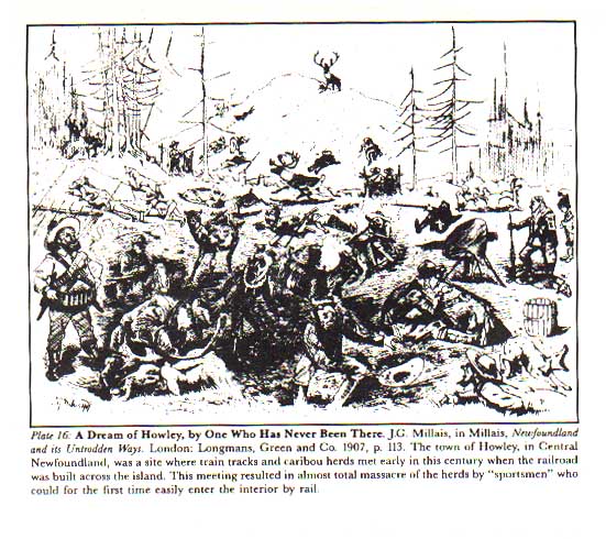
While increased human population did strain the wildlife stocks, the greatest impact on the caribou herds came from increased sports hunting and the opening of the railway in the latter years of the 1800s and early 1900s. During those years, wholesale slaughter of caribou in central Newfoundland that were easily accessible by train almost wiped out the herds.
European settlement and industrialisation of the west coast and interior did the greatest damage to the Micmac way of life. As discussed in the previous section, when whites moved in, Micmacs were forced out. As white encroachment went further into the interior, making resources scarcer and regulations more numerous, Micmacs had no choice but to adapt. Much of this process is well known; development of communities and agricultural lands disrupted wildlife habitats and forced Micmacs to use less and less territory, pulp and paper operations destroyed the forests, and eventually road construction and hydro-electric developments continued the destruction of the wilderness.
These developments eroded the Micmac way of life in another respect as well: they provided wage labour to the Micmacs who were no longer able to obtain a living from the land. So their culture, based solely on hunting, had to incorporate wage labour as well, which forced them to adopt a lifestyle more like their white neighbours. From the mid-1800s on, calls were made for regulation of settlement and establishment of better government controls on the west coast. For the Micmacs, such proposals meant that if development did not get them, bureaucracy would. From the beginning of European colonisation and settlement of Newfoundland, the aims of the Micmacs and of the Europeans were conflicting. The nature of the conflict changed, depending on the activities of both groups. In the Bay St. George and Port au Port areas, the French and Mic-rnacs managed to live together without one culture overshadowing the other. To some extent, the two groups there evolved a way of life which borrowed from both and yet retained their separate cultural identities. But both French and Micmac cultures were overriden by the British. In the end, the dominant Anglo-Irish culture of Newfoundland showed itself no more able to live alongside native cultures than anywhere else in North America.
The following section presents the economic problems the Micmacs posed for the Europeans, the solutions proposed by Europeans, and the conflicts which resulted for Micmacs.
1, 2. The/allowing reports by William Taverner, written 18 years apart, show the difficulties the British had in laying undisputed claim to Newfoundland. By the time they reached the west coast, they found Micmacs trapping, hunting and thriving economically. In order to establish their claim, the British had to limit, or preferably stop, Micmac land use.
Some Remarks on the present State of the South Part of Newfoundland humbly ofre'd to the Honble. the Lords Commrs. of Trade and Plantations by Wm. Taverner [1715]
... The French from Cape Britton as I have observed are very Industrious in spreading Reports that the Indians of Cape Britton are coming to St. Peters and the Harbrs. Adjacent to Plunder the French Inhabitants that remain there, their design in so Doing is to hinder the Inhabitants of those Places from going to Cape Ray to catch Furr, and the English Inhabitants to settle in those Harbours, their design hitherto have had the desired effect, for neither will any boat go a Furring on that Coast, nor is there one English man as yet come to settle there,... It's plain that the French, by their Strate-gems & Cunning, doth at present make that part of the Land of little or no use to Brittan, which according to my Notion, is the best part of Newfoundland for Fishing, Fowling, Furring, Masts for Ships, Trees for boards or Planck...
In my humble Opinion,... could the Indians of Cape Brittan be prevented from coming over to Newfoundland, it would be of great use to the Trade.
Source: Provincial Archives of Newfoundland and Labrador, CO 194/6 ff 47.
To the Right Honourable the Lords Commissioners of Trade and Plantations-
The humble Representation of William Taverner late Surveyor of Newfoundland [1733]
That Since his Majesty's Subjects have had possession of the West part of Newfound Land, a Considerable Number of the French Viz. Men Women and Children have from time to time Deserted from Cape Brit-ton, and Settled in and about a Certain Harbour called Portabask, near Cape Ray, the Extreme part of Newfound Land to the West...


Copyright © 2002-2003 Jasen Benwah
Thanks for Dropping By